Showing posts with label maps and earth. Show all posts

Monday 7 December 2009

Explore a whole new way to window shop, with Google and your mobile phone

What if you could decide where to shop, eat or hang out, with a little help from local Google users?

It might take you a while to ask them all, so to make it easier we've launched a new effort to send window decals to over 100,000 local businesses in the U.S. that have been the most sought out and researched on Google.com and Google Maps. We're calling these businesses the "Favorite Places on Google" and you'll now start to find them in over 9,000 towns and cities, in all 50 states. You can also explore a sample of the Favorite Places in 20 of the largest U.S. cities at google.com/favoriteplaces. Each window decal has a unique bar code, known as a QR code that you can scan with any of hundreds of mobile devices — including iPhone, Android-powered phones, BlackBerry and more — to take you directly to that business's Place Page on your mobile phone. With your mobile phone and these new decals, you can easily go up to a storefront and immediately find reviews, get a coupon if the business is offering one or star a business as a place you want to remember for the future. Soon, you'll be able to leave a review on the mobile page as well, just like on your desktop.


To scan the codes, you'll need a phone with a camera and an app that can read QR codes. For Android-powered devices, including the Droid by Motorola, we recommend using the free Barcode Scanner app. For iPhone, we have found the $1.99 QuickMark app to work best, and starting today, we're partnering with QuickMark to offer the app for free for the first 40,000 downloads. For other devices, we recommend searching for "QR reader" in your app marketplace, if it has one, or searching for the model of your phone and [qr reader] on Google. BeeTagg and NeoReader are two other apps that we've found to work well with the decals.

Here's a video that shows you how this all works:


This launch is part of our overall effort — online and offline — to provide you with the best local business results whenever you're trying to figure out where to go, whether it's a trendy Cuban restaurant in Philly, a comics shop in L.A., a hip hotel in NYC or a little bit of photographic history in Rochester, N.Y.

We plan to periodically send out new waves of window decals to qualifying businesses. If you own or manage a business and were selected as a Favorite Place, you may have already received your decal or, for most of you, it will arrive by mail in the next one to two weeks. If you weren't selected in this round, your first step is to claim your listing with Google's Local Business Center for free. That will help us determine that your business information is correct. Then, you can enhance your local business listing by adding enhanced content like photos and videos.

To explore a gallery of several hundred Favorite Places in 20 U.S. cities, to learn more about how to use the QR codes and to find out how your business can get involved, check out google.com/favoriteplaces.

Update on 12/18: If your phone does not support the mobile version of Place Pages, you will be taken to the mobile version of the Google homepage upon scanning the QR code. The QR code itself is correct and should take you to the mobile Place Page on supported devices.

Wednesday 2 December 2009

Introducing the Google Model Your Town Competition

Have you ever noticed that a lot of the bigger cities in Google Earth have photo-realistic 3D buildings in them? (See Valencia, for example.) Have you ever wondered when someone's going to get around to modeling the world's smaller towns and villages? Today, we're giving you the chance to add your own town to the map.

We're pleased to announce the first-ever, international Google Model Your Town Competition. You're invited to use our free tools — SketchUp and Building Maker — to make sure your community is represented on the world's biggest 3D stage. Every town that participates has the chance to be included in Google Earth's 3D Buildings layer where millions of people can see it. The winning town (as decided by a popular vote) will win money for its schools, a Google-sponsored party for its modelers and plenty more.

Check out this video; it highlights some of the 3D towns and cities already in Google Earth:


Visit the competition website for more information about prizes, judging and rules. You'll also find a helpful FAQ and a list of steps that should help you get started. The deadline for submission is three months away — it's not too early to form a team, take pictures and start building. Good luck!

Tuesday 10 November 2009

Fifty states of Street View

In 1959 Hawaii became the 50th state admitted to the union. Today, 50 years later, we're including Hawaii as the 50th state in Street View on Google Maps. With our imagery of Oahu and Maui, you can now take a virtual vacation to white sandy beaches, revisit special places from your honeymoon, or plan your next getaway. We've worked with the Hawaii Visitors and Conventions Bureau to create collections in our new Street View Gallery featuring Hawaii's best beaches and hometown favorites of President Obama.

Being born and raised on Oahu, I like to think we saved the best for last. I'll get you started with a tour around some of my favorite places from home.

Waimea Bay is famous for 30-foot winter waves. In the summer, as you can see in Street View, it transforms into a calm bay for snorkeling and swimming:


If you're a history buff, you can also visit Iolani Palace, a national historic landmark that was the official residence of the Hawaiian Kingdom’s last two monarchs:


This is just a small taste of all the beautiful sights in the Aloha State. Check out the gallery to see even more stunning high-resolution imagery. And now that we have imagery from all 50 states in the U.S., we've created tours of the 50 state capitol buildings for the gallery.

One of the great things about Street View is that it lets you virtually wander the streets of a diverse range of cities around the world, whether you want to gaze up at the Tokyo Tower in Japan or explore ancient Roman ruins in Italy. In addition to expanding our coverage in the U.S., today we're also adding imagery from Mexico for the first time, covering Mexico City, Monterrey, Guadalajara, Puebla, Puerto Vallarta, Cancun, Playa del Carmen and Cozumel:


As we keep working to bring Street View to new countries and cities across the globe, we want to hear directly from you about the places that you want to see featured in Street View next. A few weeks ago, we asked you to submit your nominations for places that you want our Street View trike to visit. We combed through more than 25,000 submissions and today we're unveiling the finalists. You can read more about the competition and the finalists on the Lat Long blog, and head to www.google.com/trike to cast your votes for the special locations we should add to Google Maps next.

Wednesday 28 October 2009

Announcing Google Maps Navigation for Android 2.0

(Cross-posted with the Google Mobile Blog)

Since 2005, millions of people have relied on Google Maps for mobile to get directions on the go. However, there's always been one problem: Once you're behind the wheel, a list of driving directions just isn't that easy to use. It doesn't tell you when your turn is coming up. And if you miss a turn? Forget it, you're on your own.

Today we're excited to announce the next step for Google Maps for mobile: Google Maps Navigation (Beta) for Android 2.0 devices.

This new feature comes with everything you'd expect to find in a GPS navigation system, like 3D views, turn-by-turn voice guidance and automatic rerouting. But unlike most navigation systems, Google Maps Navigation was built from the ground up to take advantage of your phone's Internet connection.

Here are seven features that are possible because Google Maps Navigation is connected to the Internet:

The most recent map and business data
When you use Google Maps Navigation, your phone automatically gets the most up-to-date maps and business listings from Google Maps — you never need to buy map upgrades or update your device. And this data is continuously improving, thanks to users who report maps issues and businesses who activate their listings with Google Local Business Center.

Search in plain English
Google Maps Navigation brings the speed, power and simplicity of Google search to your car. If you don't know the address you're looking for, don't worry. Simply enter the name of a business, a landmark or just about anything into the search box, and Google will find it for you. Then press "Navigate", and you're on your way.

Search by voice
Typing on a phone can be difficult, especially in the car, so with Google Maps Navigation, you can say your destination instead. Hold down the search button to activate voice search, then tell your phone what you want to do (like "Navigate to Pike Place in Seattle"), and navigation will start automatically.

Traffic view
Google Maps Navigation gets live traffic data over the Internet. A traffic indicator light in the corner of the screen glows green, yellow or red, depending on the current traffic conditions along your route. If there's a jam ahead of you, you'll know. To get more details, tap the light to zoom out to an aerial view showing traffic speeds and incidents ahead. And if the traffic doesn't look good, you can choose an alternate route.

Search along route
For those times when you're already on the road and need to find a business, Google Maps Navigation searches along your route to give you results that won't take you far from your path. You can search for a specific business by name or by type, or you can turn on popular layers, such as gas stations, restaurants or parking.

Satellite view
Google Maps Navigation uses the same satellite imagery as Google Maps on the desktop to help you get to your destination. Turn on the satellite layer for a high-resolution, 3D view of your upcoming route. Besides looking cool, satellite view can help you make sense of complicated maneuvers.

Street View
If you want to know what your next turn looks like, double-tap the map to zoom into Street View, which shows the turn as you'll see it, with your route overlaid. And since locating an address can sometimes be tricky, we'll show you a picture of your destination as you approach the end of your route, so you'll know exactly what to look for.

Since there's nothing quite like seeing the product in action, we made this video to demonstrate a real-life example:


The first phone to have Google Maps Navigation and Android 2.0 is the Droid from Verizon. Google Maps Navigation is initially available in the United States. And like other Google Maps features, Navigation is free.

Check out the Google Maps Navigation page to learn more and browse a gallery of product screenshots. Take Google Maps Navigation for a spin, and bring Internet-connected GPS navigation with you in your car.

Introducing the Google Earth heroes project

Hundreds of millions of people use Google Earth every day to discover, explore and learn more about the world around them. We're especially proud that Google Earth has also been used as a tool to help people change the world. Today, to celebrate he individuals and organizations that have used Google Earth in their efforts to effect change, we announced the Google Earth heroes project.

In this first stage of the heroes project, we're highlighting the work of five groups — Project Kaisei, Save the Elephants, Borneo Orangutan Survival, Chief Almir and the Surui and Appalachian Voices — who have used Google Earth in a variety of ways to tell their stories. We'll be releasing videos showcasing other organizations' work in the coming weeks, so stay tuned!

To learn more about these groups and view their videos, read our post on the Google Lat Long blog or visit http://earth.google.com/changetheworld.

Friday 16 October 2009

Street View: We can trike wherever you like

With Street View on Google Maps, you can take a virtual drive over the Golden Gate Bridge or see the bustle of Times Square from the comfort of your own home. But some of the country's most interesting and fun places aren't accessible with our Street View car. What if you want to tour the campuses of prospective universities, scout a new running trial, or plan the most efficient route to your favorite roller coasters in a theme park?

I first started thinking about this question around two years ago. My day job is working as a mechanical engineer on the Street View team, but I do a lot of mountain biking in my spare time. One day, while exploring some roads less traveled, I realized that I could combine these two pursuits and build a bicycle-based camera system for Street View. The result? The Street View trike:


I've already had a chance to take the Street View trike out to photograph some hard-to-reach places for Google Maps, like the Arastradero Open Preserve and LEGOLAND California. When I'm out riding — and once people understand what exactly I'm up to — I'm often asked if we can come to their alma mater, local bike trail or favorite beach boardwalk. Now, we're giving everyone a chance to tell us exactly where in the U.S. they'd like the trike to go next.

At www.google.com/trike, you can suggest interesting and unique spots in six categories:
  • Parks & Trails
  • University Campuses
  • Pedestrian Malls (e.g., outdoor shopping areas, boardwalks)
  • Theme Parks & Zoos
  • Landmarks 
  • Sports Venues (e.g., golf courses, racing tracks, stadium grounds)
Nominations will be open until October 28. We'll then comb through all of the suggestions and let all of you cast your final votes on a winner from each category for the Street View trike to visit. For any privately-owned or operated location, like a campus or theme park, we'll work directly with the relevant organization prior to collecting the imagery.

When we unveiled the Street View trike in the U.K., we received more than 10,000 nominations and 35,000 votes; Stonehenge and Warwick Castle were two of the top vote-getters. We can't wait to see what you'll come up with in the U.S. — head to www.google.com/trike to submit your most inspired ideas.


Tuesday 13 October 2009

Introducing Google Building Maker

(Cross-posted on the Google Lat Long Blog)

Some of us here at Google spend almost all of our time thinking about one thing: How do we create a three-dimensional model of every built structure on Earth? How do we make sure it's accurate, that it stays current and that it's useful to everyone who might want to use it?

One of the best ways to get a big project done — and done well — is to open it up to the world. As such, today we're announcing the launch of Google Building Maker, a fun and simple (and crazy addictive, it turns out) tool for creating buildings for Google Earth.

We like to think of Building Maker as a cross between Google Maps and a gigantic bin of building blocks. Basically, you pick a building and construct a model of it using aerial photos and simple 3D shapes – both of which we provide. When you're done, we take a look at your model. If it looks right, and if a better model doesn't already exist, we add it to the 3D Buildings layer in Google Earth. You can make a whole building in a few minutes.

Our early beta testers insist that Building Maker is more like a game than a tool. Check out this video to see Building Maker in action:


For now, you can choose to make buildings in any of about 50 cities. We'll keep adding more cities, but don't feel left out if we don't have your hometown yet — modeling in a place you've never been is a fantastic way to discover more about it. Teachers might find that Building Maker is a great way to get students interested in geography. Armchair tourists can not only visit an unfamiliar city; they can engage with it. It's amazing what you learn when you look at something really closely.

Here are some more things you should know about Building Maker:
  • Building Maker is an online tool, and it runs entirely in your web browser (Google Chrome, Firefox, Safari, Internet Explorer, etc.)
  • Before you can add a building to Google Earth, you need to sign in to your Google Account (so you get credit for what you contribute).
  • Models you create with Building Maker "live" in the Google 3D Warehouse (a giant, online repository of 3D models).
  • You can use Google SketchUp (our free, general-purpose 3D modeling tool) to edit or otherwise modify anything you make with Building Maker.
  • Make sure you have the latest version of Google Earth installed on your computer.
  • If you're on a Mac, you need to download the Google Earth plug-in directly.
Building Maker is free and available in 14 languages. Go to www.google.com/buildingmaker to join the worldwide mapping community. Have fun!

Friday 25 September 2009

Place Pages for Google Maps: There are places we remember!

Google Maps is a great tool for exploring places — you can pan around the map, zoom in and see nearby places, look around in Street View and search for whatever you want. But what I always wanted to do is be able to get a clear understanding of what a place is all about. Instead of doing the research all over the web, wouldn’t it be great to see all the information about one place in...one place?

Starting today, you can do that on Place Pages for Google Maps. A Place Page is a webpage for every place in the world, organizing all the relevant information about it. By every place, we really mean *every* place — there are Place Pages for businesses, points of interest, transit stations, neighborhoods, landmarks and cities all over the world.

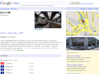
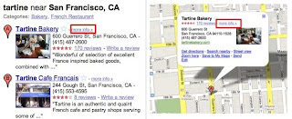
You can get to a Place Page by clicking on "more info" in search results, or by clicking "more info" in the mini-bubble. Now, instead of just getting a slightly bigger bubble, you'll get an entire page of rich details, like photos, videos, a Street View preview, nearby transit, reviews and related websites.


Here are some of my favorite places, and what you can discover about them using Place Pages:

Tartine Bakery: My favorite bakery in the world. The "Place Summary" section compiles voices from all over the web praising the desserts but warning you about the lines. The "Details" section aggregates material from over 500 authoritative sources; for example, you can find the menu from Zagat.com. The "Related Maps" sections shows user-created maps that include this bakery, such as this delicious California dessert map.


Yoda statue: One of my childhood heroes in real size! The "User Content" section shows excerpts from all over the web describing this hidden little gem; "Nearby Transit" helps you find the best way to get there by public transport; and there’s even some useful local ads in case you want to get one of these at home.

Tokyo: I've spent a lot of time here lately as it's home to part of the Place Page team. On the city's Place Page, you can find out the most popular hotels, parks and major landmarks in Tokyo, browse local photos and videos, see what other people are searching for and access maps about the city from all over the web.

Zurich Hauptbahnhof: I’ve traveled through the central train station in Zurich several times over the last year, visiting the local team that made Place Pages possible. Place pages for transit stations are particularly useful because they'll show you a list of all the lines serving that station, as well as provide a timetable of upcoming departures. 


As the Beatles' song in this post's title suggests, we want to make it easy to remember places: pages will come with a friendly URL that is easy to remember and link to under google.com/places. For example, the San Francisco Place Page will be found at google.com/places/us/california/san-francisco-city. Right now we include cities and most businesses, but we're working hard on bringing this to all Place Pages.

We want there to be a Place Page for every place in the world, but we might be missing a few places here and there. If you're a business owner, you can add or update your business details through the Local Business Center. This allows you to make sure your Place Page reflects the most accurate, authoritative and recent information about your business. And if you don’t have a business, but you discover a place that doesn’t have a Place Page, you can add it through community edits or Google Map Maker, depending on the country you’re in.

Whether you're searching for a great local florist or planning a trip across the globe, we hope Place Page for Google Maps makes your explorations easier and happier.

Tuesday 22 September 2009

Google climate change tools for COP15

In December of this year, representatives from nations around the globe will gather in Copenhagen to discuss a global agreement on climate change. The objective is to reduce global warming emissions sufficiently in order to avoid the most severe impacts of climate change and to support the global community in adapting to the unavoidable changes ahead. Denmark will act as host for this fifteenth Conference of the Parties under the United Nations’ Climate Change Convention, known as COP15.

In collaboration with the Danish government and others, we are launching a series of Google Earth layers and tours to allow you to explore the potential impacts of climate change on our planet and the solutions for managing it. Working with data from the Intergovernmental Panel on Climate Change (IPCC), we show on Google Earth the range of expected temperature and precipitation changes under different global emissions scenarios that could occur throughout the century. Today we are unveiling our first climate tour on Google Earth: "Confronting Climate Change," with narration by Al Gore. Stay tuned for more tours in the coming weeks!

Together with the Danish government, we're also launching our YouTube COP15 channel. On the channel, you can submit your thoughts and questions on climate change to decision-makers and the world through an initiative called "Raise Your Voice." These videos will be broadcast on screens around the conference in December and rated by viewers of the channel. The top-rated contributions will be aired globally during the COP15 CNN/YouTube debate on December 15th, and the top two submissions will win a trip to Copenhagen. We look forward to seeing your videos!

Tuesday 25 August 2009

The bright side of sitting in traffic: Crowdsourcing road congestion data

This post is the latest in an ongoing series about how we harness the data we collect to improve our products and services for our users. - Ed.

What if you could do a little something to improve the world during your daily drive to work? Here are a few ideas: tell everybody in the city when you're stuck in slow-moving traffic; warn the drivers on the freeway behind you that they should consider an alternate route; tell the people still at home that they should spend another ten minutes reading the morning news before they leave for work; tell your city government that they might want to change the timing of that traffic light at the highway on-ramp. Of course, you can't just get on the phone and call everybody, and your one traffic report from your one spot on the road might not help much anyway. But if everybody on the road, all at once, could tell the world how fast their car is moving, and we could make it easy for anybody to check that information on their computer or cell phone, well — then we'd be getting somewhere.

If you use Google Maps for mobile with GPS enabled on your phone, that's exactly what you can do. When you choose to enable Google Maps with My Location, your phone sends anonymous bits of data back to Google describing how fast you're moving. When we combine your speed with the speed of other phones on the road, across thousands of phones moving around a city at any given time, we can get a pretty good picture of live traffic conditions. We continuously combine this data and send it back to you for free in the Google Maps traffic layers. It takes almost zero effort on your part — just turn on Google Maps for mobile before starting your car — and the more people that participate, the better the resulting traffic reports get for everybody.


This week we're expanding our traffic layer to cover all U.S. highways and arterials when data is available. We're able to do this thanks in no small part to the data contributed by our users. This is exactly the kind of technology that we love at Google because it's so easy for a single person to help out, but can be incredibly powerful when a lot of people use it together. Imagine if you knew the exact traffic speed on every road in the city — every intersection, backstreet and freeway on-ramp — and how that would affect the way you drive, help the environment and impact the way our government makes road planning decisions. This idea, which we geeks call "crowdsourcing," isn't new. Ever since GPS location started coming to mainstream devices, people have been thinking of ways to use it to figure out how fast the traffic is moving. But for us to really make it work, we had to solve problems of scale (because you can't get useful traffic results until you have a LOT of devices reporting their speeds) and privacy (because we don't want anybody to be able to analyze Google's traffic data to see the movement of a particular phone, even when that phone is completely anonymous).

We achieve scale by making Google Maps for mobile easy to install and use, and by making it easy for people to provide information about their own vehicle speed. There's no extra device to plug into your car and no extra software to buy. Google Maps is free and works with most cell phones, and the number of cell phones with GPS is rising every day. Some phones, such as the T-Mobile myTouch 3G and the Palm Pre, come with Google Maps and traffic crowdsourcing pre-installed (the iPhone Maps application, however, does not support traffic crowdsourcing). Google is fortunate to have a lot of people using our products, and that scale helps make our products better.

We understand that many people would be concerned about telling the world how fast their car was moving if they also had to tell the world where they were going, so we built privacy protections in from the start. We only use anonymous speed and location information to calculate traffic conditions, and only do so when you have chosen to enable location services on your phone. We use our scale to provide further privacy protection: When a lot of people are reporting data from the same area, we combine their data together to make it hard to tell one phone from another. Even though the vehicle carrying a phone is anonymous, we don't want anybody to be able to find out where that anonymous vehicle came from or where it went — so we find the start and end points of every trip and permanently delete that data so that even Google ceases to have access to it. We take the privacy concerns related to user location data seriously, and have worked hard to protect the privacy of users who share this data — but we still understand that not everybody will want to participate. If you'd like to stop your phone from sending anonymous location data back to Google, you can find opt-out instructions here.

We've already been able to provide useful traffic information with the help of our existing mobile users, but we hope that is just the start. As GPS-enabled phones and data plans get less expensive, more people will be able to participate. Crowdsourcing traffic gives us a way to harness bits of location data from our users and give it back to them in a form they can use to make impactful decisions that affect their free time, their pocketbooks and the environment. The more people use it, the better it will get. So next time you're sitting in morning traffic, turn on Google Maps for mobile and let someone else know they can hit the snooze button one more time. Tomorrow morning, they might do the same for you.

Friday 24 July 2009

Google Latitude on your iPhone

Earlier this year we announced Google Latitude, a service that lets you and your friends share your locations with each other. You control who gets to see your location and where on the map you appear to others. Today, we're releasing Google Latitude for iPhone and iPod touch, available in the Safari browser.

Visit google.com/latitude from your device to start using Latitude. Add a bookmark to your home screen to quickly launch Latitude. Just open Latitude in Safari and tap the + icon > Add to Home Screen > Add. For more details, check out the Google Mobile Blog.


Monday 20 July 2009

Explore the moon in Google Earth


[From time to time we invite guests to blog about initiatives of interest, and are very pleased to have Anousheh Ansari join us here. – Ed.]

Ever since I was a young girl, it has been a dream of mine to travel into space. In September of 2006, I was fortunate enough to make that dream a reality — I took off from the launch pad in Baikonur bound for the International Space Station and became the world's first private female space tourist. Since then, it's been my mission to help as many people as possible think ambitiously about ways to push the boundaries of exploration, both here on Earth and beyond. As a trustee of the X PRIZE Foundation, and the sponsor of the Ansari X PRIZE, I support Google's goal of opening up space through projects like the Google Lunar X PRIZE, which serve to educate the public about the global benefits of space exploration.

That's why I'm so excited about the release of Moon in Google Earth, which is launching today at the Newseum in Washington D.C. This tool will make it easier for millions of people to learn about space, our moon and some of the most significant and dazzling discoveries humanity has accomplished together. Moon in Google Earth enables you to explore lunar imagery as well as informational content about the Apollo landing sites, panoramic images shot by the Apollo astronauts, narrated tours and much more. I believe that this educational tool is a critical step into the future, a way to both develop the dreams of young people globally, and inspire new audacious goals.

With Google Earth, young explorers around the world can bounce around the galaxy in Sky, fly to Mars and now visit the moon from wherever they may be. To learn more watch the video below or visit the Lat Long Blog. Finally, outer space doesn't seem so far away anymore.

Thursday 16 July 2009

Introducing a collection of favorite places from around the world

We on the Google Maps team are committed to organizing all the local places and businesses that can be found online, from a design shop in New York City, to an architectural bookstore in San Francisco, to a cabaret in London. To show you the range of all this interesting local information, we've teamed up with local experts around the world to share some of their favorite places.

Culinary expert and chef Alice Waters has shared her favorite places for organic and sustainable food in San Francisco and the Bay Area, including places like Blue Bottle Cafe, whose coffee Alice serves at Chez Panisse in Berkeley, and Bi-Rite Creamery, where you can find salted caramel ice cream.

Iwona Blazwick, director of the Whitechapel Gallery in London, has shared her favorite places to experience art in London, from the Tate Modern for contemporary art to Curzon Soho cinema, where you can catch the latest independent film releases.

Vladimir Spivakov, artistic director and principal conductor of the State chamber orchestra Moscow Virtuosi and the National Philharmonic of Russia, has shared his favorite places to hear and appreciate theater and music in Moscow, from the Moscow Conservatory, where he studied, to the historic Maly Theater, the oldest theater in Moscow.

With this project we also hope to send a friendly message to local businesses — people are looking online for local information, and you should be here. Timothy Childs, Founder and Chief Chocolate Officer of TCHO in San Francisco, shares his perspective on using online tools to build and grow:

"TCHO is all about using appropriate technology, to make high quality chocolate and experiences for our customers. As our start-up moves to early growth stage, we are now using tools like Google Maps and the Local Business Center to reach customers and to continue building our business."

It's estimated that 80% of U.S. Internet users use web search to find restaurants, stores and other local businesses, and yet only about half of local businesses currently have a website. By working with local experts to highlight the power of the web, we're encouraging local business owners to build out their online presence. If you're a business owner looking to get online, have a look at the Google Local Business Center.

To browse the full collection of favorite local businesses and places, visit google.com/favoriteplaces or m.google.com/fav from your phone's browser.


Special thanks to all the participants and partners around the world who helped to make this project possible, including United Airlines, NYC & Company, Time Out and Le Figaro.

Friday 10 July 2009

Seeing the world with improved Google Search results

As an avid traveler, I know how helpful it can be to see a map when searching for a location on Google. Using our Universal Search technology, we have provided maps in our search results for more than two years. However, as any traveler could tell you, knowing the geographical location of a place is only part of the story. It's often just as valuable to get a sense of what the place is like, and there's no better way to do that than by looking at images of some of its most important sights.

Now, when you search for locations using Google Search, you may see pictures from that place alongside a map. You can click on any of those images to go to the photos layer on Google Maps where you can browse many more geo-tagged photos.

So if you searched for [Paris], you'd see:


Here's [Yellowstone National Park]:


We think this is a great way to get a better sense of a location as well as get a taste of some of the great user-contributed photos that await on Google Maps. We hope you'll have a fun time exploring!

Monday 8 June 2009

Design It Shelter Competition: Unleash your inner architect

Today, Frank Lloyd Wright's 142nd birthday, we're excited to announce the Design It: Shelter Competition. Held by the Guggenheim Museum and Google SketchUp, the competition is inspired by Wright's assignment for his apprentices at Taliesin: If you wanted to study to be an architect with Wright, you had to design and build a shelter in the desert outside of Phoenix, Arizona. Then you had to live and study in it.

Unlike the Taliesin assignment, the shelters in this competition are virtual. To enter, use Google SketchUp to design a small structure where someone might sleep and work. Your shelter should be created for a specific site anywhere in the world and geo-located in Google Earth. It also should conform to size constraints and must not include running water, gas or electricity. When you're done with your design, upload it to the Google 3D Warehouse, then fill out the submission form on the Guggenheim website. Check out the video below to learn more:


The deadline for submissions is August 23rd. You can find more details, including information about judging and prizes, on the the Google SketchUp Blog or the competition website. Good luck!

Tuesday 2 June 2009

The Local Business Center dashboard opens its doors

If you're a local business owner, it's likely that Google plays a role in helping customers find you. And we're not just talking about your website — thanks to Google Maps and Google Search, you may also be getting a lot of online traffic to your business listing. You've probably seen one of these listings before:

You also probably know how they tend to work: A potential customer does a search on Google.com or in Google Maps, comes across your listing, clicks on it to see your reviews and details, and then gets directions to your location.

Now, imagine if there were a way for you to get a better understanding of how those customers are finding you. Did they search for "pizza" or "pasta" to get to the listing for your Italian restaurant? Do they live across town, but drive miles for your great selection of camping gear? What happens to traffic to your new dental practice when you start advertising in the local paper? With information like that, you'd be able to make better informed decisions on how to drive more traffic to your listing and attract more customers.

Later today, you'll be able to do just that, thanks to a new dashboard feature we're launching in the Local Business Center (www.google.com/lbc). The LBC is a free tool that enables business owners to control the content of their business listings as they appear in Google Search and Google Maps. All you have to do is claim your listing in the LBC and go through a quick verification process to get access to the following kinds of data:
  • Impressions: The number of times the business listing appeared as a result on a Google.com search or Google Maps search in a given period.
  • Actions: The number of times people interacted with the listing; for example, the number of times they clicked through to the business' website or requested driving directions to the business.
  • Top search queries: Which queries led customers to the business listing; for example, are they finding the listing for a cafe by searching for "tea" or "coffee"?
  • Zip codes where driving directions come from: Which zip codes customers are coming from when they request directions to your location.
The new dashboard will also let you dig into that data using all kinds of lists, maps, and graphs like this one, which measures impressions and actions for a hotel's business listing:


When you sign in to the LBC today, you'll find that we've already populated the dashboards for claimed listings with data from the last 30 days. After that, new information will be added every day, so you can check in often to see how things are going. We're also working hard to add more historical information, and to make this available for businesses outside the U.S. All the data we share through the dashboard will be anonymous and aggregated, to protect the privacy of Google users.

We're really excited to be able to open up this data to local business owners. Before now, you could track usage metrics on your website using a tool like Google Analytics, but data about how customers found you in other ways never got back to you. That all changes today, and we think business owners will really get a lot out of this new information. So if you're a local business owner and you feel the same way, be sure to check out this new dashboard.

To learn more about accessing and using the dashboard, take a look at the video below and then visit the Lat Long Blog for a more in-depth overview.


Thursday 21 May 2009

Congratulations Eric Yang, winner of the 2008-2009 National Geographic Bee

1. Timis County shares its name with a tributary of the Danube and is located in the western part of which European country?

2. Name this eastern European capital city, where a flight from the southeast would approach the city by flying over the Rhodope Mountains.

3. Name this city in Oceania, the largest on South Island, where a flight from the west would approach the city by flying over the Southern Alps.


If you're stumped, you're not alone! For 55 fourth- to eighth-graders, though, these sorts of questions represented the culmination of months of hard work studying maps and absorbing geographic knowledge.

Earlier today I had the honor of speaking at the championship round of the 2008-2009 National Geographic Bee — moderated by Jeopardy!’s Alex Trebek for the 21st year. This year, Google Earth is sponsoring the Bee in support of its mission to raise awareness and support of geography education. Held at National Geographic’s Washington, D.C. headquarters and broadcast on public television stations across the country, the competition inspires and challenges students to better understand the world around them. 

Eric Yang, who didn't miss a single question in the finals, won on the third question of a tiebreaker round by answering the first question above. Eric, a 7th grader from Texas, has already scored 2200 on his SATs!

It wasn't just the students who came away from the day re-energized and excited about geography. I was also lucky enough to meet a number of passionate educators like Rebecca Montgomery, a teacher from Mississippi, who administered the state bee there this year and told me that "the bee had a tremendous impact on our schools this year and I know now what we need to do to get kids ready to learn geography."

Here at Google, we're always excited to see how innovative teachers are using tools like Google Earth and Maps to engage students by putting the world's geographic information at their fingertips. I'm particularly happy to have been part of the Bee today because geography and mapping were such a big part of what led me to help create Google Earth. I'm not the only Googler who fell in love with maps at an early age, though. Check out this video to see how some of my fellow mapmakers started down the path that eventually brought them to their current profession:


We'll be watching to see what lies ahead for today's passionate young geo whizzes. Congrats again to all the Bee competitors, and happy exploring!

Answers: 1. ɐıuɐɯoɹ 2. ɐıɟos 3. ɥɔɹnɥɔʇsıɹɥɔ 

Wednesday 13 May 2009

A planetarium in your pocket

At today's Searchology event we were pleased to launch Google Sky Map for Android. Google Sky Map turns your Android-powered mobile phone into a dynamic window on the night sky. When you point your phone upwards you will see a map of the brightest stars, constellations and planets in that part of the sky. The next time you see a bright star and want to know what it's called, Sky Map can help you identify it.

Whether you are an aspiring astronomer or just want to impress your date, download Sky Map from the Android Market. For more information watch the video below or visit the Lat Long Blog.


Wednesday 6 May 2009

More tools and tricks for teachers

Hello teachers,

We hope that your desk was deluged with a bunch of shined-up apples this morning as a thank you from your students for all that you do for them every day. At Google, we'd like to thank you as well, and acknowledge that we wouldn't be where we are today if it hadn't been for the great teachers who mentored us through school.

In support of National Teacher Day, we'd like to announce that applications are open for our next Google Teacher Academy, which will take place in our Boulder, Colorado office on Wednesday, August 5th. The Google Teacher Academy is a free professional development experience designed to help K-12 educators get the most from innovative technologies. Each academy is an intensive, one-day event where participants get hands-on experience with Google's free products, which will help you bring communication, collaboration and fun into your classrooms. Teachers will also learn about innovative instructional strategies, receive resources to share with colleagues, and immerse themselves in an innovative corporate environment. Upon completion, participants become Google Certified Teachers who share what they learn with other K-12 educators in their local region. Applications are due Friday, July 3rd.

We'd also like to thank our cadre of Google Certified Teachers, who spread all kinds of professional development love every day. Specifically, we'd like to highlight GCT Jerome Burg, whose Google Lit Trips was recently awarded the 2008 Goldman Sachs Foundation Prize for Excellence in International Education in Media and Technology. Google Lit Trips uses the technologies of Google Earth and social networking to bring literature to life through virtual mapping. By placing markers on Google Earth tracking the journeys of characters from literature and populating those placemarks with a wide variety of supplemental resources, students can “ride along as virtual passengers” on the same journey the characters are taking. The site gives teachers access to previously constructed Google Lit Trips as well as the ability to interact and post new trips online. Congratulations, Jerome — you couldn't have made us prouder!

Tuesday 17 March 2009

Building bridges

Since Google SketchUp first popped up on the scene in 2006, we've had the pleasure of seeing many of you use it to build 3D models of all kinds of things -- from college campuses to furniture to gingerbread houses. Now, we're happy to announce a new challenge -- the SketchUp 2009 International Student Bridge Modeling Competition. Bridges are some of the most breathtaking architectural structures in the world, and we're sure you have an impressive model of a local, famous or historical bridge right up your sleeve. Students at higher education institutions are qualified to compete, and it's easy to enter. Just model your bridge in Google SketchUp, geo-reference it in Google Earth, and upload your submission to the Google 3D Warehouse anytime before June 15.

For more information, check out the Google SketchUp blog. We're excited to see what you come up with!